Hiking Shasta County’s Clear Creek Trails
Let’s start off with showing my favorite trails here in Shasta County (California). I LOVE the Clear Creek trails, these trails are on BLM land and since they aren’t in the city limits they allow off-leash. Here is a link to the BLM page if you scroll down to “Clear Creek Greenway” you can get information including maps. If you have ever been these trails, share your barks with me!
If dirt trails are not your thing or these are too far, Shasta County has a bark-load of trails. You can find most of these trails listed here on Healthy Shasta’s Website. I will try to review more of these trails in the future.
Here are some screen shots of one of our recent hike. This particular hike was on the Piety Hill Loop, but we started at the Horsetown trailhead and did a modified loop. Doing the trail this particular way has so many hills it turns into a bum-barker, you will be feeling this hike if you are not used to hills.
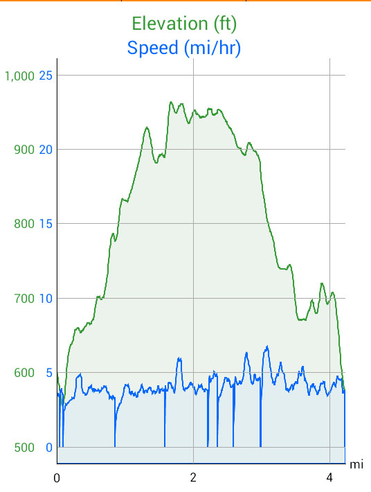
Elevation and speed chart of our hike, it shows a couple times we had to stop for fellow hikers and riders.

Map of our hike
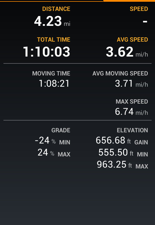
Stats on our hike

Hiking the Piety Hill Loop
Excuse the poor photo quality, the camera on the phone is having issues.

Oct 29, 2015 @ 01:47:49
As for the trail names, I made them up or used names that other people had given them on other maps. Bee’s Knees was named by the bkiers. I named the Gila View one and the Kebo Trail which is named after a mountain in Maine. I need to go back and work on my maps as my stuff is old now. I sat with the rangers last week going over their vision for that area and what trails they want to keep open or perhaps close. I’m hoping to influence them to keep open some of of the historic trails although there are a few that should not be embraced or hiked due to erosion issues. But there are several mine trails that are in pretty good shape and challenging to hike that should remain in my opinion. There are many old trials down that way I’ve been on that I haven’t mapped too for the purpose of keeping them natural as they are now. In most instances these trails are really overgrown.FYI, I was up on Pyramid this morning so we might have passed each other on the path.